The hike to the Mexicano Falls Overlook is yet another crown jewel hike of Big Bend Ranch State Park. It’s truly phenomenal.
I grew up extremely religious, learning more prayers and psalms than your average pastor. There’s one prayer, called the Magnificat, which includes this line:
“My soul doth magnify the Lord and my spirit rejoices in God my Savior, for God has looked with favor on the lowliness of the Almighty’s servant.”
I long ago left behind the cultish practices of my childhood, but…
Well, you can take the girl out of the church, but you can’t completely take the church out of the girl. This prayer often springs to my mind unbidden when I am on a particularly awe-inspiring hike. This trail evoked those ancient lines of “my soul doth magnify the Lord…” through my mind multiple times.
It is a Magnificat hike.
Table of Contents
My Packing List for Mexicano Falls
- The 10 Essentials (duh!)
- Water and lots of it! At least 4L, preferably not all in one container
- Snacks – minimum of 600 calories
- Sun hat
- Sunscreen
- Rain jacket
- First aid kit
- Paper map & compass
- Navigation app such as Gaia GPS
- Emergency communication device such as a Bivvy Stick
- Power bank like Nitecore
- Cord for power bank & your devices
- Headlamp or flashlight
- Leave trip plans in front seat of car & with a responsible person not with you
Safety Concerns Hiking Mexicano Falls
Before we get too far into the hike, let’s get one thing absolute-fucking-lutely straight. This trail is not for the rookie, the cocky know-it-all, or the physically less-than-fit. And as much as I love hiking solo, I’d strongly recommend against hiking this one solo.
This is a physically challenging hike with multiple opportunities for falls and injury.
Mexicano Falls Trail is Hard to Navigate
The bigger concern on this trail, however, is wayfinding.
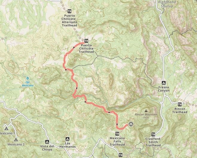
On the map, which you can pick up by request at a ranger station, this trail is marked as a “route” – it’s not even a proper trail! Apps like Gaia GPS do not give you this key piece of information and instead list it as any other trail in Big Bend Ranch State Park. It’s not.
Because this trail is a “route” and not a trail, it is not well maintained (and that’s saying a lot for Big Bend Ranch State Park). Most of the trails in this park aren’t “well maintained”, so this is even worse than the average for the rest of the park.
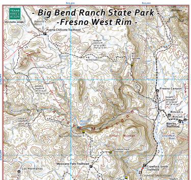
Note the “dots”. These represent “routes”, which are less maintained/harder to follow than the “dashes”, which are trails
Navigating by Cairn
Often the only means to tell the way forward is to stand at the highest point near a cairn and desperately scan the desert scrub for the next one. And then you have to pick the least prickly path to the next said cairn, praying you don’t get assaulted by a cacti in the process.
Bring a Paper Map
If you want to avoid getting hopelessly lost without cell service, a paper map is a must. And you’ll want a detailed paper map, not just the big exploration map. The detailed map can be found online and downloaded here.
I was extra cautious and asked the rangers to print out the Fresno West Rim Trails for me at the Sauceda Ranger Station. I recommend anyone going out there take all three.
Be Proficient with Compass and Bring Your GPS
In addition to the map, you really must bring (and know how to use) a compass. Knowing how to locate North on the compass doesn’t count as being proficient, by the way. I would also recommend a GPS device (we use a Bivy stick) and a navigation app such as Gaia GPS.
You can use your devices to track your path in the background, but I wouldn’t have them out as a primary method of navigation unless you have spare battery power for days. Maybe literally, given that you can lose power to heat and from leaving your screen on too much.
You must, must, must be proficient at navigation to attempt this trail!
Sounds like overkill?
Here’s How We Navigated Mexicano Falls
Maybe it is but in the case that you get lost, you’ll be glad to have them all. I hiked this trail with my husband, who , unlike me, is quite proficient in the use of a paper map and compass. Prior to starting the hike, I turned on Gaia to track our steps. Jon scoffed at me and said we wouldn’t need Gaia. For the worst case scenario, we carried the Bivy stick which we can use to call for rescue.
As previously mentioned, my darling husband Jon felt like having Gaia running continuously was superfluous (and battery sucking), but we were glad to have it running on our way back. When we got temporarily mis-located, using the app allowed us to quickly retrace our steps.
We could have found the trail with a map and compass if my phone had died, but it would have taken longer and we were in a race against daylight. Better safe than sorry!
Accessing Mexicano Falls & Crawford-Smith Overlook
Ok, now that we’ve covered safety, let’s get back to the trail talk (even better than pillow talk IMO).
We started this hike from the Puerta Chilicote trailhead. The road driving in was slow and a bit rough but we were easily able to access it with our 2 wheel drive Honda Pilot.
Of note along the road is a small arroyo a ways before you reach the trailhead – if you’re driving a smaller vehicle, you’ll want to park in the first parking area which you’ll find before hitting this small gulch. The main trailhead parking is on the other side of it.
Pro tip: Always chat with the rangers about current road (and trail) conditions before heading out, as these can change unexpectedly. Don’t take our experience of backcountry conditions as gospel! The rangers at Sauceda ranger station tend to be the most up to date on current conditions in the park but as of January 2025, this station is not reliably staffed.
Puerta Chilicote Trailhead
There are two trail signs here. If you’re planning to get to Mexicano Falls or the Crawford-Smith overlook, you want the Cerro Chilicote Loop.

Importantly, you’ll find two composting toilets at the Puerta Chilicote Trailhead. When you’ve been shitting in a wag bag or bucket toilet system, this is quite the luxury.
Not to be indelicate, but you’re not going to find a better spot to dump out all day. Real ones know how it is.

Map at the trailhead. Stick to the right hand trails to get to Mexicano Falls.
Hiking Puerta Chilicote to Mexicano Falls
This relatively flat, easy 1.5 mile trail showcases interesting scenery, very typical of Big Bend Ranch State Park. You will get to see all kinds of desert flora along this trail. As an added bonus, this trail is easy to follow – no advanced wayfinding skills required (yet).
The last bit of this trail runs through a sandy creek. Here we followed bear tracks until we came out of the wash to take the Mexicano Falls Trail.

Mexican Black Bear tracks!
Coming out of the sandy creek bed, we were greeted with this beauty (below).
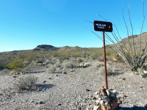
Note the cairns and the rocks laid out in a row.
Following Cairns on Mexicano Falls Trail
From this point on, the main way to follow this route is via stacked cairns, and rocks purposefully laid out in a row. In my opinion, finding cairns isn’t too challenging when hiking downhill. Unfortunately, it becomes considerably more difficult – when going uphill (on your way back) – a fact we had not yet learned.
The route takes on a rolling character here – frequent small descents and ascents. We startled a herd of mule deer early into this section of the trail, who seemed quite offended by our rude intrusion (not that I can blame them).
The first really interesting feature of this trail is an orange/yellow colored rock field. It looks as if a magma flow crossed this section of land and dried to form the current landscape.
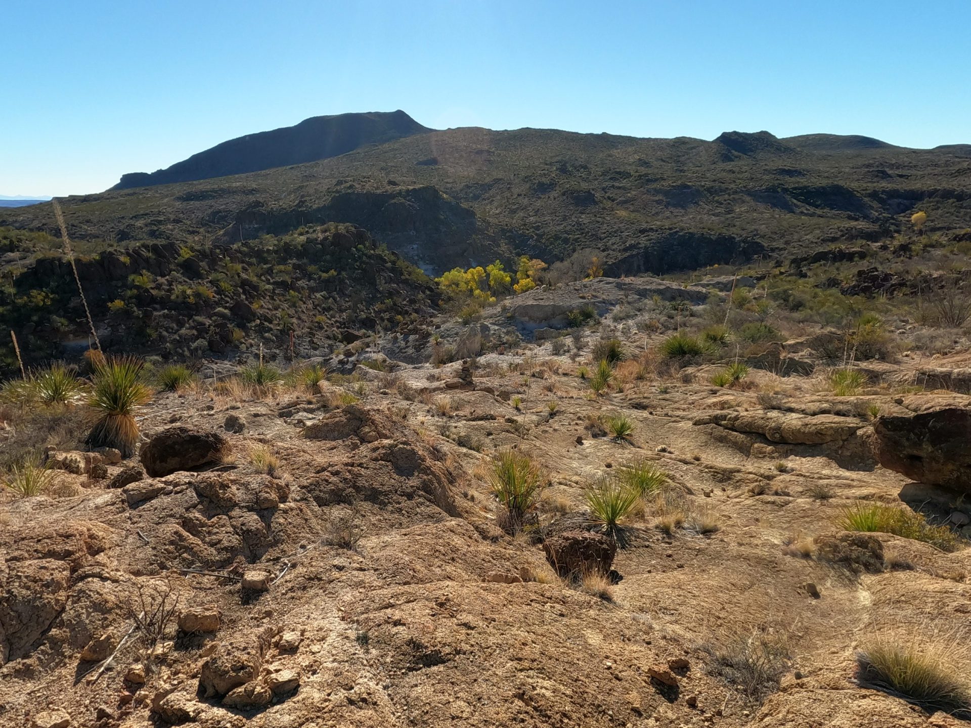
It may not look super cool from the picture but it’s pretty awesome in real life.
Almost immediately after this flowing rocky section, the route descends into a small canyon. This is where the fun begins.

The slightest touch of a scramble here!
There is just the tip of rock scrambling here and the trail is made up of loose scree. Take a moment to admire the “cave” across the way and give your complaining quads a quick respite, as this section is fairly steep and technical.

See the little “cave” in the upper right hand of the picture?
Watch your ankles here!
Think this section is cool and exciting? From here the trail only gets more thrilling. Buckle up.
Mexicano Canyon
Another steep, rocky climb takes you down in the bed of good ol’ Mexicano Canyon, where we ran into more black bear tracks (no scat) and trees in full fall foliage.
This would be a great place for an extended rest break in the shade of some trees.

You will walk through Mexicano Canyon for a very short bit – less than ¼ of a mile. Keep an eye out for the trail out of the canyon on the right. After a steep, kinda shady scramble on loose rock up the opposite side of Mexicano Canyon, the views really open up.
My eyes naturally flowed down the length of Mexicano Canyon from above (and my mind began to recite that damn prayer).

Looking down into Mexicano Canyon
Leaving Mexicano Canyon
From this point, the trail heads away from Mexican Canyon for a short distance. Then it runs roughly parallel to Mexicano Canyon again for the rest of the hike to the Falls Overlook.
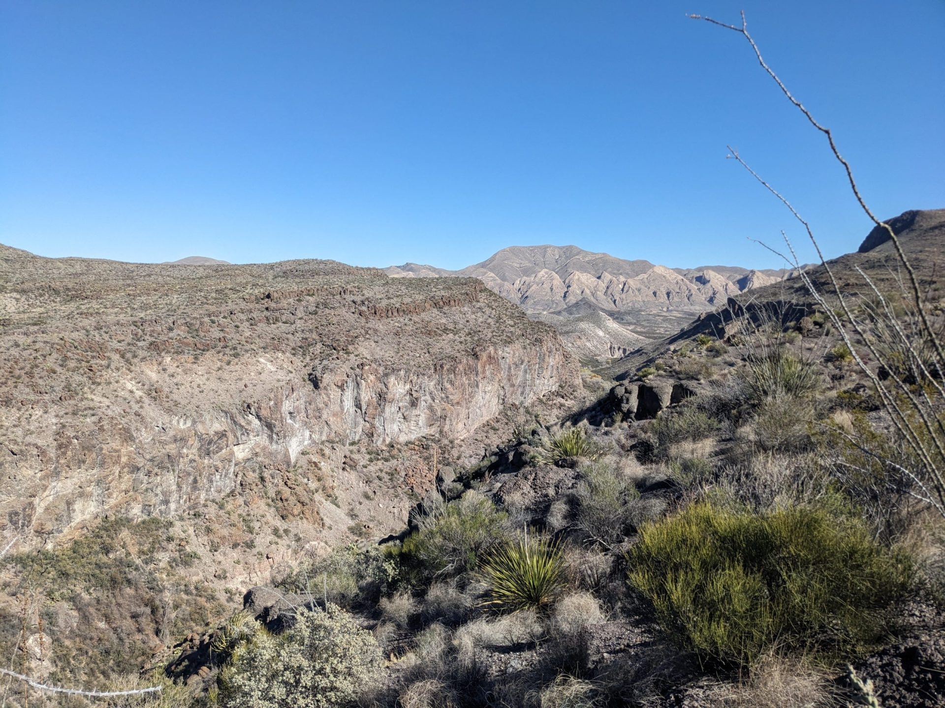
Mexicano Canyon. Notice the Flat Irons in the background.
Once you are out of Mexicano Canyon and on your way to the climax of the overlook, the route is particularly hard to follow.
There is no trail. You have to work your way carefully from cairn to cairn. If you haven’t already started it, now is the time to turn on your GPS tracking device. Something like Gaia GPS can make retracing your steps on the way back MUCH easier.
Ahem. More about that later on.
Watch for Rincon Mountain
Once you start to see mountains on the right and the canyon on your left you’re getting really close to the overlook. The backside of Rincon Mountain towers in front of you – beautiful but I’d say that her front side is the better view (you’ll see that if you go to the Fresno West Rim overlook, also pictured on this map).
Mexicano Falls Overlook
The trail map says that the Mexicano falls overlook is 4.3 miles from the Puerta Chilicote Trailhead and it was actually dead on.
Blink and there the falls are, a massive concave bowl dominating the canyon. There is no marking, no sign, that *this* is the Mexicano Falls Overlook but once you see it there is no doubt.

She may not be super photogenic but IRL she’s a beaut
As soon as I laid eyes on this glory from the past, the words of the Magnificat ran through my brain again and again. The picture doesn’t come even close to doing this beauty justice. The sheer magnitude of this former waterfall cannot be captured in a mere photo.
Sit your ass down, break out a snack or lunch and feast your stomach and eyes on this glory. Ferns grow in the “bowl” part of the waterfall, a strange contrast with the rest of the austere desert shrubbery.
As far as the eye can see the land stretches out around, endless rolling of canyon, hill and mountain. Nowhere is there any sign of civilization, not even an airplane in the sky. The feeling of solitude is a little overwhelming.

The day we went, the air was still and quiet. Silence lay all around us and rejuvenated me on a deep level. It also made my eventual return to the noisy city really fucking hard. If my husband and daughter hadn’t been with me, I would have taken any excuse to spend more time there.
I could have sat reading or scribbling nonsense in my notebook for hours.
From Mexicano Falls to the Crawford-Smith Overlook
After taking an extended lunch, we ventured a touch further to see the Crawford-Smith Overlook. If you are a strong hiker and have the time and energy, there are three other overlooks and three marked waterfalls in the area.

Waterfalls & overlooks to explore galore for the true adventurer!
For that matter, if you’re a good driver with a high clearance four-wheel drive vehicle, you can make the trip down to Mexicano Falls Trailhead. From there, you can hit up several overlooks with rather less effort than it took us. Is that really experiencing Big Bend Ranch as it’s meant to be enjoyed? Is that an authentic experience?
For no rational reason, I want to say “no” but I have no logic upon which to ground that argument. But I digress…
One of the things that’s really frustrating about BBRSP is that the trails are often not named on their maps. Looking at the Fresno West Rim map or the Exploration Map, you will see that there is an unnamed .8 mile trail that T-bones into a .3 mile trail.
We took this .8 mile trail, which gently rolled along, and then turned left on the T-bone to a dead-end at Crawford-Smith Overlook. The .3 miles to the overlook is, kindly put, overgrown with minimal trail and no cairns.
Fortunately, at the end you will be at the Crawford-Smith Overlook, which is something to be Magnificat about.
Pay close attention to your surroundings as you go. And again, I highly recommend having a GPS tracker running throughout this whole area.
Crawford-Smith Overlook
Once you reach the Crawford-Smith Overlook, it also isn’t marked but there is no fucking doubt that you have arrived. The cliffs drop away and open up in front of you for miles on end. It’s a classic desert overlook, by which I mean to say that it’s incredibly beautiful.
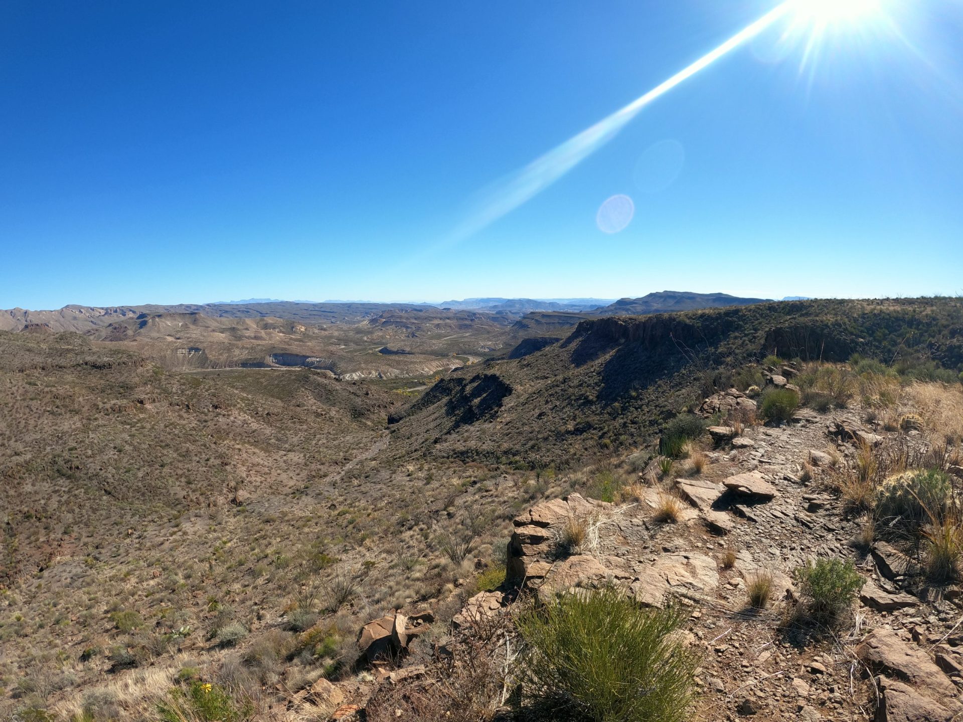
From here you can catch a glimpse of the Crawford-Smith House, the Flatirons and Rincon Mountain. It’s hard to say which is more stunning – the Mexicano Falls or this overlook.
But if I’m honest and you twist my arm for an answer, Crawford-Smith may have made me squeal just a touch more than the falls did.
It is not to be missed. Don’t be a sissy and turn back at the Mexicano falls. At least make it to the Crawford-Smith Overlook if it is safe for you to do so. Don’t trust the pictures – they’re fucking liars and don’t nearly do this place justice.
This is a place to be experienced, not merely ogled via photo.
Navigating back from Crawford-Smith Overlook
From the Puerta Chilicote Trailhead, the mileage to this point was 5.42 miles with an elevation gain of approximately 1000 feet. It took us a total of 3 hours 14 minutes to reach the overlook with a 10 year old in tow.
Mind you, my girl has a walking six pack and isn’t exactly your average 10 year old when it comes to fitness. Your mileage may literally vary.
Much as I wanted to continue on to hit up the other overlooks or even a waterfall or two, at this point we tucked tail and headed back for the Puerta Chilicote trailhead. There’s a limit to what even our very fit and patient 10 year old will tolerate.
Following Cairns on the way back was hard
Bolstered by the confidence that we’d successfully navigated the route without too much difficulty – which we’d heard was “so hard” – we got lost in conversation and didn’t pay as much attention to the cairns on the way back as we should have.
All of a sudden we found ourselves in a particularly rocky, overgrown section of land, unable to see any cairns in any direction. We wandered about a bit, looking for cairns, completely flabbergasted that semi-experienced navigators like us could make such a heinous mistake!
What the hell was this?!
Eventually, with the help of GaiaGPS and a bit of wandering up and down the hill, we were able to retrace our steps. The experience taught me an important lesson that I mentioned before: cairns can be much harder to follow uphill.
Going downhill, you can often see a line of them and know roughly where you are headed at a glance. Uphill, you’re lucky if you can see one at a time.
A Detour Along Ojo Chilicote
At the end of the 2.8 mile Mexicano Falls Trail, we took the Ojo Chilicote Trail (the 1.1 mile route on the map) instead of taking the 1.5 mile Cerro Chilitote Trail back. We then linked up with the unremarkable Puerta Chilicote trail back to the trailhead. Taking this detour allowed us to see the Ojo Chilicote spring near the end of our hike.
The spring wasn’t orgasmically awesome, but it was certainly pretty. There are trees (duh, there’s water) and, due to the winter season, lovely colorful leaves. There are also some interesting rock features in the area of the spring.
Compared to sections of the Mexicano falls route, Ojo Chilicote trail wasn’t too terribly hard to navigate. Nonetheless, we definitely had to keep a sharp eye out for cairns to keep the path. I’ll admit it was slightly harder to navigate than I anticipated (or was ready for at the end of a taxing day).
Puerta Chilicote Trail is boring but short
The last little bit of trail, the Puerta Chilicote section (clocking in at .6 miles) is a total bore. Slog through until you hit the trailhead where the luxury of a composting toilet and your car await.
Too Long: Didn’t Read;
Would abso-fucking-lutely recommend.
- Hard to navigate, especially on return journey
- Too dangerous/remote/difficult to hike solo
- Trail can be as short as 8.6 miles round trip or much longer if adding other overlooks
- Takes you to the Mexicano waterfalls overlook
- Goes through a section of Mexicano canyon
- Rugged, challenging hiking with loose rock and a few scrambles
- Only for the fit, experienced hiker with significant navigation proficiency
